


The Mountains At The Bottom Of The World - 1: Massif Attack
An Everything Is Amazing encore edition!

Hello! This is Everything Is Amazing, a newsletter that tries to annoy your curiosity so much that you spend the rest of the day obsessively reading about things you never realised you didn’t know.
(This is a lot more fun than getting tricked into reading about rubbish you’re not the least bit interested in.)
Once again, this is a repeat edition from EiA’s earlier seasons (2021-2022) while I’ve been taking a short break before launching season 6 in September. (If you missed it, the last one - about the cognitive glitches that mess with our working curiosity - is here.)
This is the first of a two-parter, as befitting a subject matter on a scale that even surpasses the mighty Zanclean Megaflood from a few newsletters back. If you have a hat, hold onto it.
But before we start and for no reason other than LOL, happy 10th-and-a-bit anniversary to one of the greatest newspaper corrections of all time:


Anyway. Today, a piece from season 4 - and the surprising answer to an interesting question: what does the world’s longest mountain chain look like?
I thought I already knew. I bet you do too. Maybe you’re imagining the Himalayas - 2,500km long. Or maybe you’ve been caught out by this before during sessions of Trivial Pursuit, or at a pub quiz, and you’re thinking of the Andes, nearly three times longer with an incredible 7,000km end to end.
Nope. Not even close. The length of the record-holder is 65,000km (40,000 miles). That’s long enough to wrap around the Moon six times.
And yes, this is on Earth and not on the Moon, or anywhere else. I’m not cheating. It’s here, and it’s absolutely real.
Let’s start with the part of it that most looks like any other mountain range you’ve ever seen.
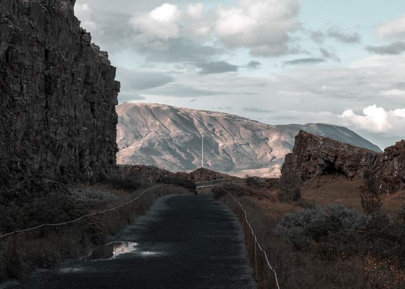
This is perhaps the only place where it’s practical to hike these mountains: Þingvellir National Park, east of Reykvavik in Iceland. Along its Almannagjá Gorge, pictured, you can see North America slowly backing away from Europe - or vice versa, depending on how you feel about these things.
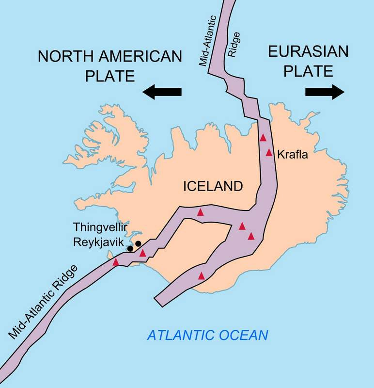
It shows that Iceland is a divided country, but not in the way news headlines like to bang on about. Underneath it, the North American Plate - the vast slab of rock that underlays the whole of the United States and stretches as far as Russia - butts up against the Eurasian Plate (everything east of Iceland, until it circles the globe and hits the North American Plate on the other side).
Geologists describe these plates of rock as “floating”. This is one of those instances where modern science uses an everyday word in a way that’s factually more or less correct, but it also requires…a certain amount of getting your head round, if you don’t work in that scientific field.
In this context, it means “basically solid rock moving around on top of a layer of equally solid but rather more dense rock”: the former being crust (the stuff our continents are made from, plus the stuff in between them at the bottom of the oceans) and the latter being mantle, a layer of hotter, denser rock that goes down for thousands of miles and makes up 85% of the bulk of our planet (also called the asthenosphere).
If your imagination’s wrestling with analogies involving rubber ducks in the bath - well, sort of? But only if - erm - the rubber duck was continually being remade out of the bath-water it’s bobbing around on?
(This is why scientists understandably lose patience when non-experts like me resort to analogies: there’s a point where a ‘simpler’ version gets even harder to explain than what’s actually going on.)
Another way that “floating” falls short is that the plates aren’t bobbing around at random: they’re being pushed apart.
Far below the Þingvellir National Park, rock is slowly pushing its way upwards, squirting up between the Eurasian and North American plates. That pressure is filling the space between them with new rock, remaking Iceland from the bottom up - and pushing each continental plate away from its neighbour, at the rate of a few centimetres a year.
In a few million years, Iceland may be hundreds of kilometres wider in both directions - or it’ll have split in two, or reared and sunk into the surrounding oceanic crust, or something even weirder. The only certainty here is that it won’t look anything like it does today.
This is what’s doing it:
All this is fairly recent news, by the way, and not just to me. The science of plate tectonics, or tectonophysics, only really took off in the early 20th Century, although hats off to Leonardo Da Vinci for deducing some of it, along with many of today’s accepted principles of geology, centuries before everyone else (what a dazzling mind he had!).
This is where our journey begins.
For practical reasons we’ll have to imagine a truly colossal budget for the following undersea journey. Without expensive equipment, you’d be feeling…really quite uncomfortable within the first half-hour, due to your lungs collapsing and your blood fizzing like shaken lemonade. I would not wish this upon you, and it would not do great things for my word-of-mouth marketing. (“My partner read Mike’s newsletter and then he exploded. Cannot recommend.”)
Instead, like Neil deGrasse Tyson in the recent reboot of Cosmos, we’re taking a “ship of the mind,” equipped with everything we could possibly need - and one of those things is a detailed map of where we’re going.
Of everything we’re conjuring up, this might be the most fanciful leap of all - because even today, it’s mostly unclear what the majority of the Mid-Atlantic Ridge looks like at a practical, human scale.


Massimo’s tweet is broadly correct in one sense and mistaken in another: it’s untrue that nobody knows the very broad shape of what’s at the bottom of the oceans - but most existing maps only have a resolution of 5km or more, which is where that rough estimate of 5% comes from.
I mean, imagine this with a land-map you’re trying to use! Anything smaller than 5km wide vanishing into the background noise - including most mountains (when classed as “anything over 300 metres high”).
The same applies at sea as well. Except down there, mountains are called sea mounts. And in the middle of the 20th Century, they started becoming a real problem for the submersible navies of the world. How much? Hard to say, since military organisations have a habit of keeping details of such accidents to themselves for security reasons.
But here’s one story we now know about:
“In 2005, the nuclear attack submarine USS San Francisco suddenly stopped dead in its tracks. The ship's crew were thrown about, some over distances of 20 feet, and the majority of the 137-member crew suffered one injury or another—including one that would later prove fatal. Further inspection would explain what happened, and reveal that the submarine's bow looked like a crushed soda can. USS San Francisco had run into an undersea mountain.”
- “15 Years Ago, a U.S. Navy Submarine Ran Into a Mountain,” Kyle Mizokami, Popular Mechanics
Not to worry you, but we’ll shortly be heading for one of the bigger sea mounts, as we descend into the waters off Iceland. It’s some way off, but it’s worth the visit, as you’ll see. And we’ll even take in a Lost City along the way!
(No, not Atlantis. We’re sticking with the known science here.)
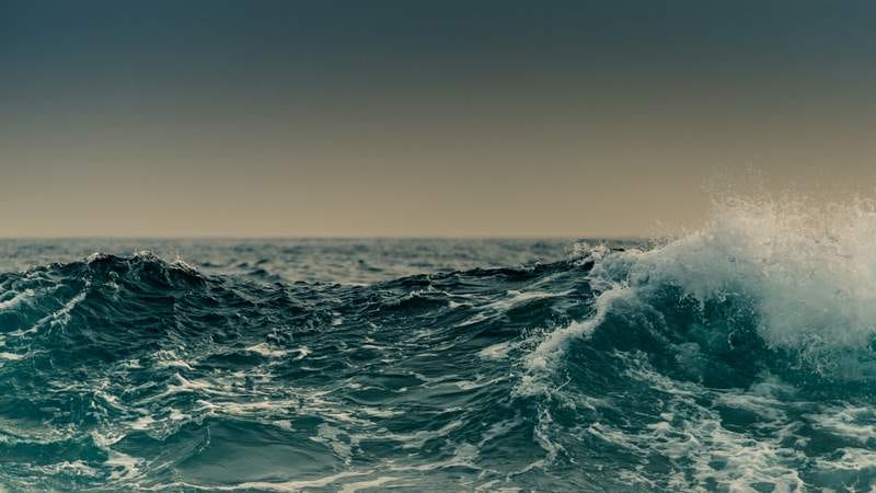
Sorry about the view ahead of us, by the way:

Past about 1,000 metres deep, all our oceans are like this.
This is a problem not just in the obvious way - we need to bring our own lights, and even those won’t shine very far, even in calm conditions - but also because of a terrestrial bias we landlubbery creatures have: our perception is so dominated by our vision that we struggle to imagine scale that extends beyond how far we can see. (It also messes with our ability to judge distances! Greaaaaat.)
The clearest seawater in the world will let you see about 80 metres. So that’s mostly where our visual imaginations stop, unless we apply effort to them. And for those special individuals lacking a '“Mind’s Eye” (known as Aphantasia, an inability to conjure up mental images) - well, I don’t know actually, is that going to help or hinder you here? Any volunteers? Maybe you can steer our ship for a while, and if we crash, well, isn’t that interesting?
(Also interesting: a recent psychology paper that suggests it may be possible to spot aphantasia in someone from the way the pupils of their eyes react to light.)
For all these reasons, we need good, reliable maps - and these only started to come together properly in the 20th Century. In the case of the Mid-Atlantic Ridge, we have two people in particular to thank - geologists Marie Tharp and Bruce Heezen, whose work overturned the common assumption that the floor of the Atlantic was mostly flat and featureless:
“Navy regulations meant Tharp couldn't go out on the research vessels that Ewing and her other colleagues chartered. Even if she had, they would not have been hospitable places for women (one of the deep sea cameras Ewing took on his journeys was affectionately dubbed “The Pyrex Penis” due to its phallic appearance). Instead, she stuck to her drafting table, collaborating with geologist Bruce Heezen on a map of the ocean floor.
For years, Heezen collected the data while Tharp crunched the numbers and charted them out. It was thankless work in a time before computers; Tharp had to comb through an enormous pile of sonar soundings and plot out her measurements by hand. Still, she found inspiration in the very mystery of the task. “The whole world was spread out before me,” she recalled in a 1999 essay about the Lamont-Doherty Earth Observatory. “I had a blank canvas to fill with extraordinary possibilities ... It was a once-in-a-lifetime—a once-in-the-history-of-the-world—opportunity for anyone, but especially for a woman in the 1940s.”
Then, something unexpected showed up on Tharp’s canvas: a huge valley in the middle of the gigantic ocean ridge she was mapping. It was so deep that she kept re-checking her calculations. If it was what she thought it was, she would have evidence of a rift valley inside a ridge at the bottom of the North Atlantic Ocean.”
- “Seeing Is Believing: How Marie Tharp Changed Geology Forever,” Erin Blakemore, Smithsonian Magazine
Nowadays, we know it broadly looks something like this spectacular map from 1977, created using Tharp’s and Heezen’s data:
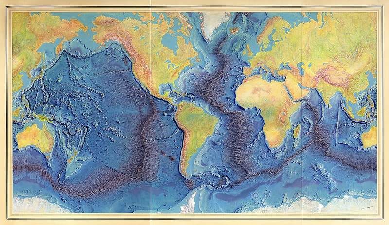
And for a close-up of the Atlantic, check out this utterly beautiful NatGeo relief map from 1968.
One thing to note: as is customary for relief maps, the vertical scale is exaggerated. But both these maps do convey the staggering magnitude of what we’re looking at: a rift valley comparable to the Grand Canyon, but stretching for … how far? The Atlantic portion is about 16,000km, but it’s also connected to other oceanic trenches of a similar nature, creating a continuous chain running for 65,000km.
It is, by far, the longest mountain range on our planet - and also, arguably, the least accessible.
This isn’t idle hyperbole, and I’m including the ends of the earth here. Yes, Antarctica’s Transantarctic Mountains are terrifyingly inhospitable, being not too far away from where the coldest temperature ever recorded on our planet - minus 89.2°C - was measured in July 1983. But in instant lethality, that’s small potatoes compared with what would happen to you in a split-second were you to step outside your submarine into an Abyssal Zone, with more than 4 kilometres of seawater pressing down on you.
(This is…not a time where I’m going to link to a scientific paper. Deeply horrifying, all of it.)
So, all well and good. What happens on the sea floor stays on the sea floor. We squishy fragile bags of caffeine and anxiety (just me?) keep our distance and admire these geological monstrosities from afar, and everyone’s happy. At least, that was the thinking before Tharp and Heezen got busy.
But then they started finding how big these sea mounts were - or rather, how tall.
Here’s the biggest discovered to date in the Atlantic, located just south of the Azores:
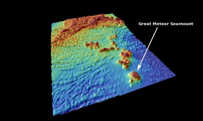
It rises 4.5km (around 14,800 feet) from the sea floor to almost reach the surface of the Atlantic, with a summit that’s just 270 metres deep. For comparison: it’s about the size of Spain’s Gran Canaria, with an elliptical plateau covering 1,500 square km.
And despite that size, it was only discovered for the first time in 1927.
During the paranoia of the Cold War era, this was information the US Navy desperately wanted - not just to keep its submarines safe, but also to scout out possible hiding-places for Soviet forces. (Sounds ludicrous, but - I come from a country that annexed a tiny, birdshit-spattered fleck of rock off the Scottish coast in 1955 because of an absurd fear the Russians might build a missile battery on it, so *shrug*.)
For security/paranoid reasons, Tharp & Heezen’s data was initially kept under wraps - and it was also treated with some skepticism. In 1957, a doubtful Jacques Cousteau set out to test Tharp’s rift valley thesis in one of his submersibles - and to his astonishment, found it exactly where she’d mapped it to be.
Tharp died in 2006, but the mapping continues to this day. As an example, you only have to look at the incredible work done by a team led by David Sandwell, an oceanographer at the Scripps Institution of Oceanography (La Jolla, California).
In 2014, he published a map mainly using data from two satellites: the European Space Agency’s CryoSat-2, and Jason-1, from NASA & the French space agency (CNES).
Putting an astoundingly complicated thing insultingly simply: it turns out that when there’s a large, dense mass at the bottom of the ocean, it generates just the tiniest amount more gravity than flat ocean floor - and that extra gravity drags just a little more seawater on top of it (because water doesn’t compress under pressure). A tiny rise on the surface of the sea.
By cancelling out background noise, Sandwell’s team could use it to create a gravity-map of the sea floor. And by “background noise” I mean - the movement of the sea. The waves. They filtered out the waves.
Science writer Phil Plait (now on Substack with his superb Bad Astronomy Newsletter) explained how they achieved this mindblowing scientific feat in this article at Slate from 2016.
The upshot? Newly-discovered mountains. Thousands of them:
“In the old map, scientists could detect the underwater volcanoes known as seamounts if the features rose more than about 2 kilometres from the seafloor. In the latest map, as many as 20,000 previously unknown seamounts, between 1.5 and 2 kilometres high, pop into view scattered along relatively young sections of the sea floor…”
- “Gravity map uncovers sea-floor surprises,” Alexandre Witze, Nature (2014).
It’s really quite astonishing that less than a decade ago, this single piece of data analysis discovered almost twice as many sea mounts as there are mountains in Switzerland. (!!)
So - what else is down there?
» Next time in Part 2: A Mountain, A Lost City - And Life? «
You might also enjoy a piece behind the paywall on the Great Pangean Mountain Trail - thousands of miles longer than the mighty Appalachian Trail, and actually walkable - if you had a few years to spare, of course…
With that in mind: would you considering upgrading to help this newsletter exist - and get access to all that paid stuff as well? (And I really do mean “help exist” - this thing is 100% reader-supported, and as of last year, it’s my main gig as a writer. Paid subscriptions are how I keep this newsletter advertising-free and stay focused on writing stuff directly for you, not for sponsors and all that muddlesome stuff.)
If you’d be willing to help, now’s a great time! For the next 11 days, all paid subscriptions to Everything Is Amazing are 10% off.
This will give you access to all those paywalled articles (like this recent one about a seemingly hollow mountain in the Himalayas); free access to the upcoming, revamped version of my non-fiction storytelling course (the first draft of which existing paid subscribers went through last year); chapters from my also upcoming first book How To Be Rained On; and a 1-to-1 ‘curiosity call’ to motivate you to chase your own weird-but-thrilling obsessions, as I explained here.
If you’re interested, thank you *so* much, that would mean everything to me. Click below to sign up, get that 10% discount & help keep this thing alive!
Images: Gunnar Sigurðarson; Berann/Heezen/Tharp; Mario Caruso.
.jpg)