The Mountains At The Bottom Of The World - 2: Atlantis, A Lost City, And...Alien Life?
Yes, this is a proper science story, I promise.
Hello! This is Everything Is Amazing, a newsletter about curiosity, science, and the boundless joy of a really good Wow! that you feel right down to your boots.
If you’re new here, or this is the first time you’ve opened this thing - hello! I’m thrilled you’re stopped by.
This is a mostly free newsletter, organised loosely in the form of seasons - and to access almost all of the archives for seasons 1 (here), 2 (here) and 3 (here), and keep getting most of this thing landing in your Inbox every week, you will never have to pay a penny. This I vow on my honour, in that special old-timey way that British people are properly good at.
But then, you’d never see what that extra 20% has to offer.
You’d miss a special newsletter coming over at the end of next week - and you’d miss other paid-subscriber-only newsletters coming in the future (particularly in the gaps between seasons). And you couldn’t read all the paywalled ones in the archives, like this one. And you won’t get to see anything of the book I’m writing (about the joy of rain!) - and you won’t get access to my upcoming storytelling course for free.
If you’d rather not miss out on those things, would you be interested in becoming a supporter of Everything Is Amazing - and help me grow this thing until I’m able to make it everything it could be?
(Thank you! Seriously. It means the world to me.)
Anyway - if you wish I was still writing about amazing atmospheric phenomena like I was last season, this should properly tickle your fancy:
Paul is a landscape photographer, but he’s now rejigged his career around chasing red sprites, the rare - and, as you can see, huge - electrical discharges that can blaze around the top of thunderclouds. Read more about his work here.
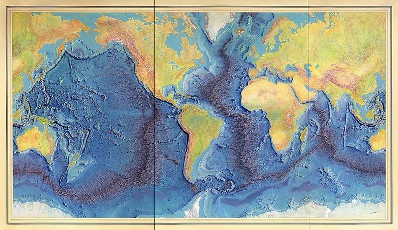
So - in today’s story, we’re plunging back under the waves for the second half of our imaginary journey along our planet’s biggest mountain chain.
We rejoin our submersible of the imagination in the profoundly black depths of the Atlantic - and on all sides of us, unseen, is a rift valley.
That’s a term you may have encountered before, so let’s latch onto it. This is a chasm formed by two tectonic plates drawing away from each other, and the rent in the earth’s that’s left can go seriously deep. Siberia’s Lake Baikal sits on top of an active rift valley. It’s both the deepest lake in the world, with a maximum depth of 1.6 km - increasing by a little every year as the valley widens further - and it also holds 20% of all the liquid freshwater on our planet.
(Read that sentence again if you like. It’s a real brain-flopper.)
Or maybe you’ve heard of East Africa’s rift valley, which stretches for thousands of miles, and includes Lake Tanganyika, which is the second-deepest lake in the world and contains the second-biggest amount of freshwater. Hope you see the pattern here.
Here’s a modest-sized rift valley in Ecuador just getting itself going:
But the biggest rift valleys are the undersea trenches, and they’re on a scale that, if you could actually see them, would make your knees weak. Over the last few million years, the creeping apart of the continental plates has created oceanic valleys that are up to 15km from one side to another - and that plunge straight down a thousand metres or more from the surrounding mountainous sea floor.
We’ve ended up in one right now, on approximately the same latitude as north Florida and southern Morocco. We’re really deep, way past the point where any light can filter down, and far into the bloodcurdlingly-named Abyssal Zone, the region of the sea at a depth between 2km and 6km. (If all this was a game of Subnautica, you’re going to need the heavily reinforced Prawn Suit, my friend).
What a magnificent word “abyssal” is, by the way. It’s from the Greek word that means “no bottom” - and you can see why James Cameron used it to title one of his most underrated films, filled with scientific details that teeter right on the edge of being possible, as I wrote about previously.
But the formal scientific title for this underwater region is technically the “Abyssopelagic Zone.” Erm? Yeah - me neither. Let’s stick with abyssal.
Anyway. Thus defined, the Abyssal Zone is the biggest environment on our planet’s surface that currently holds life: 300,000,000 square km in total (115 million square miles), or about 60% of the Earth’s surface…
Except, we’re doing that thing with big numbers that are too big to mean anything. Let’s try to wrestle all this down to a more human scale.
Where we are right now, we’re taking a hard right, to follow the slowly curving distant rift valley wall. As it abruptly plunges to over 5,000 metres deep, the Mid-Atlantic Trench is swinging west, into a huge transform fault, where the vast ocean plates to the north & south are slowly grinding past one another. This fault jinks the sea floor westwards, momentarily interrupting the passage of the Mid-Atlantic Ridge before it continues southwest:
And as we head up and out into this vast dogleg canyon, our sonar readings are going crazy. There’s something really huge to our right - a mountain far bigger than the others surrounding it. It’s so big that it’s nearly reaching the surface, even from way down here. That’s…kinda nuts?
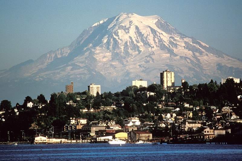
It’s called the Atlantis Massif - while there are no photos available to effectively convey its size for obvious reasons, here’s a well-known land-based mountain of about the same dimensions:
This is Washington State’s Mount Rainier, seen from Tacoma. With a summit height of 4,392m, it’s one of the highest mountains in the US.
Almost exactly like Rainier, the Atlantis Massif is around 16km across, and climbs over 4,200 metres - which gets its summit to within 700 metres of the sea surface, rising all the way from the bottom of the Mid-Atlantic Ridge. If you put Rainier and this monster of a seamount next to each other, they’d look all of a pair. It’s just huge.
(Like I said last time, it’s easy to misconstrue the scale of oceanic geology just because it’s underwater, where we’re biased to think of things as small. Not so! Like, REALLY not so.)
We’re rising up the side of the Atlantis Massif now - and after some time, we’re moving up onto a rock shelf about 70 metres from the summit. And ahead, out of the darkness, something wholly unexpected catches the light of our floodlights.
White towers, some of them a hundred metres tall or more, spread over an area comparable to a city block.
What? Wait! “Atlantis Massif”? OMG! IS THIS…?
Okay, hold your horses. It’s not really a city. And it’s certainly not that city, the mention of which crops up in any discussion about underwater exploration (which is surely a testament to our love of a good story). But this is worth a full-throated OMG.
Welcome to one of the strangest and mysterious places on our planet, filled with secrets that could change our understanding of how life gets started - including the kind that might exist elsewhere in our Solar System.
This place is called the Lost City Hydrothermal Field (clearly they couldn’t shake off the whole Atlantis thing either).
From the top of these bone-white spires spews hot fluid filled with hydrogen and minerals - and it’s the minerals that have formed these ghostly structures, the calcium reacting to the carbon in seawater to form calcium carbonate, the main ingredient of eggshells, sea shells and that pesky limescale that builds up in your kettle.
But that’s not what makes this place so special:
“Discovered in 2000, Lost City is one of only a few known places like it on the planet. Unlike more common types of hydrothermal vents, such as black smokers and methane seeps, Lost City is not fueled by volcanic activity. Rather, the vents are created when seawater encounters rock from the Earth’s mantle, creating gas and energy in a process known as serpentinization. Calcium-rich water from these vents then reacts with carbon in the seawater to form Lost City’s iconic carbonate chimneys.
Hydrogen gas spewing from the chimneys provides an ample energy source for the microbes living in Lost City. “It’s the closest thing to a free lunch the universe provides,” Brazelton says. The chimneys also release methane, an organic molecule which is a rich source of energy for many types of life.”
- “Diving Deep to Reveal the Microbial Mysteries of Lost City,” Anna Kusmer, Smithsonian Magazine (7th September 2018).
Almost all terrestrial forms of life on our planet get their energy directly, or not particularly indirectly, from the Sun. We landlubbing creatures are used to thinking in this way: if there’s life, there’s surely a food-chain that leads up towards the light? Of course there is. How else would it work?
The discovery of life around hydrothermal vents, getting its energy not from sunlight but from chemical processes that can be trace downwards, into the depths of the Earth - is one of the greatest scientific discoveries of the last 50 years. It means that life can emerge in places that don’t, and have never, been part of a solar-powered biological energy cycle…
And it turns a tiny moon of Jupiter into potentially one of the most exciting places in the known universe.
Europa has the bizarre property of apparently being the smoothest body in our solar system. It’s covered with a layer of ice, crazied with cracks and striations, but apparently intact - and smooth. What this screams is “youth!” If it was old, it’d looked as pockmarked as our Moon, or perhaps smashed into the celestial equivalent of a Slush-Puppy. But it’s not - and that suggests some kind of process of renewal of the integrity of that surface ice.
The best bet is an ocean - except, it’d have to be a sea on a scale absolutely alien to us. Scientists now think Europa’s icy crust is up to 25km thick, floating on a mostly liquid water ocean that’s between - *takes a big breath* - 60 and 150 kilometers deep.
This means that while this small moon is only a quarter the diameter of Earth, its ocean may contain twice as much water as all of Earth’s oceans combined.
If it turns out that Europa has active hydrothermal processes pumping heat into those terrifying depths of that ocean - it’s now possible to imagine a way for life to thrive with any need for sunlight, based on known science. It seems it’s happening here. It might be happening there. It’s that simple - and maybe some day in the not-too-distant future, we’ll be able to discover if it’s true or not.
Okay! For now, I’m afraid it’s time to leave the Lost City and head south for a few thousand miles, to the drop-off point where this tour - and this particular stretch of the world’s longest mountain range - ends.
I'm hope you’ve brought a warm coat?
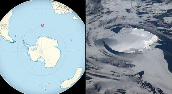
Welcome to Bouvet Island! Isn’t it lovely?
And by lovely I mean “horrifyingly bleak, 93% glacier-locked, bitterly cold and exposed, and hugely uninhabited since forever.” But it’s also where the Mid-Atlantic Ridge ends, at the triple-boundary between the Africa, South American & Antarctic plates. And since it’s where I stop getting paid for this tour by the hour - everybody ashore please.
As I wrote for CNN Travel a good while back:
“Its cliffs are sheer. It's almost entirely covered by a glacier. In winter, its seas are pack ice. And its nearest neighbor is Antarctica, 1,000 miles to the south. In short, idyllic.
Reaching Bouvet: The entire island is a nature reserve - so unless you can make a compelling case for visiting, you'll be blocked by Norwegian authorities. Get permission, and it's now a simple matter of finding a research vessel, quickly mastering a valuable skill such as arctic geological surveying or marine biology and then getting someone to land you via helicopter. (There are no ports or harbors.)
If all else fails, try becoming an amateur radio enthusiast: In 1990, a multinational expedition of operators spent 16 days on the island.”
So I really hope you’ve arranged for forward transportation of some kind, because I’m not lingering. Brrrrr.
(What, you didn’t read the tour brochure? Oh dear. You’re in for an uncomfortable…however long it takes to get rescued. Best of luck, I guess.)
Thanks for coming along!
- Mike
Images: Berann/Heezen/Tharp; CreationLaw/Wikimedia; Lyn Topinka/Wikimedia; NOAA Photo Library expl2282 / Wikimedia


All of this is just so amazingly cool! Having lived in Seattle, I appreciate the reference to Mt. Rainier because i have a really good idea what that is like in scale. And when you fly in and out of Seattle you sometimes bank right around that mountain top, so it's easy to imagine these crazy huge pillars on it. And storytelling course? yes please!
So much delight here, as always! And Lake Baikal -- tell me you've seen this?! https://www.youtube.com/watch?v=mn4oanrNQV0
#lifegoals